
RISON - Not many people have floated the entire length of the Saline River from its origins north of Benton to its confluence with the Ouachita River, but Pat Jo Keegan of the Mt. Carmel community is among them.
Keegan, who is the District 4 Justice of the Peace on the Cleveland County Quorum Court, developed a passion for the outdoors at an early age. However, it wasn't until her career with the military that took the Rison High School graduate to South Dakota that she really found her passion: kayaking.
That passion followed her on her return to Arkansas, and she made it her goal to float the entire 204-mile length of the river. Keegan's experience with the Saline is the focus of this week's episode of the Herald's Free Range Conversation podcast, which can be accessed through the newspaper's website at clevelandcountyherald.com or can be download through Spotify, Apple or nearly any of platform available for podcasts.
"My parents raised me on that river," Keegan said. "We had a cabin down at Mt. Elba. That's where I learned to swim. "And when I got out of the military and went through my speed bump in life and moved from South Dakota back to Arkansas, I was already doing kayaking with the Outdoor Women of South Dakota which was like a Game & Fish program," she said.
Keegan said she went through the Outdoor Women program in South Dakota more than a dozen times. The program offers weekend classes on a wide variety of outdoor interests, ranging from hunting and fishing to trapping and floating. Keegan said the Arkansas Game & Fish Commission has similar program called Becoming an Outdoor Woman (BOW), Keegan said.
Keegan points out that she did not float the entire length all at one time. Instead, she said she and a high school friend, Joe Paul Harrell, would take in different sections of the river whenever they could fit in their work schedules. She also noted that they did not float the sections in any particular order.
"We broke it up into manageable fractions because of work schedules, and water levels and forecasts as far as the weather goes," she said. "We would get in about two to three floats in a year." She said it took them about seven years to complete the entire length.
The Saline River is considered perhaps the state's most overlooked float stream. It is the only undammed stream in the Ouachita Mountains watershed, and it is feed by the South, Middle, Alum and North forks, all of which flow through forested land before converging north of Benton to form the Saline. Keegan said she has not been able to find any official designation of where the Saline River actually begins.
The Nature Conservancy considers the Saline to be the equal to the Buffalo, Mulberry or Cossatot rivers in terms of water quality. "The Saline is one of the most pristine watersheds in Arkansas," said Chris Davidson, endangered species coordinator for the U.S. Fish and Wildlife Service, told The Nature Conservancy. "It's rich in fish and mussel species." Keegan said the river changes drastically from its origins north of Benton to its outlet into Crossett Bay along the Ouachita River. She described the upper Saline as being narrow with clear water and a gravel or shale bottom. As the Saline flows southward, it becomes wider, and the water becomes more murky. She also noted that the number of access points diminish the farther south the river goes.
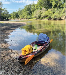
She said one of the biggest issue she encountered along her venture was trees being in the river. She said it was a huge problem as they tried to float the section of river between Hwy. 270 in Grant County and Hwy. 167 in northwest Cleveland County.
"The only put-in and take-out is on (Hwy.) 46, which is about 20 miles from 270, and about 20 miles to 167," Keegan said. "So we had to bring all of our camping gear with us since there was no put-in our take-out." She said several times during that stretch they would have to take their kayaks out of the water, either drag them over the trees in the river or go around them on the bank. "It was really rough," she said.
While fallen trees are also an issue another the lower Saline, Keegan said there are more anglers that use that part of the river so they often bring chainsaws to cut a path through the river.
Keegan advises those who want to float the Saline, especially in Cleveland County, to be sure to check the river levels first at Rye first. The National Water Prediction Service, a division of NOAA, measures the water levels along the Hwy. 63 bridge just south of Rye. Those measurements can accessed online by searching for "Saline River water level at Rye" in Google or other search engines.
Keegan said the ideal conditions is when the river levels are are at 5 to 7 feet. Any deeper than that she said there are no shoals or sandbars to pull up on. She said experienced floaters could still float at 9 feet, but the current will be very strong. "I don't care to float if it's over 7 up to 7.5 feet," she said. "I like stopping and enjoying the river."